1985–2024 年 30 米分辨率全球年度火烧迹地数据集 (GABAM) 正式发布,提供免费下载

数据集描述
年度火烧迹地面积(Annual burned area)被定义为全年度内发生的火灾空间范围,不包括往年发生的火灾。
GABAM 数据集是基于 Google Earth Engine (GEE) 平台的自动化处理流水线,利用 GEE 上所有可用的 Landsat 卫星影像生成的。该产品采用地理坐标系(经纬度投影),分辨率为 0.00025°(约 30 , with the WGS84 horizontal datum and the EGM96 vertical datum,使用 WGS84 水平基准和 EGM96 大地水准面。数据集由 10°×10°的分幅组成,覆盖范围为西经 180°–东经180° and 北纬80°–南纬60°。
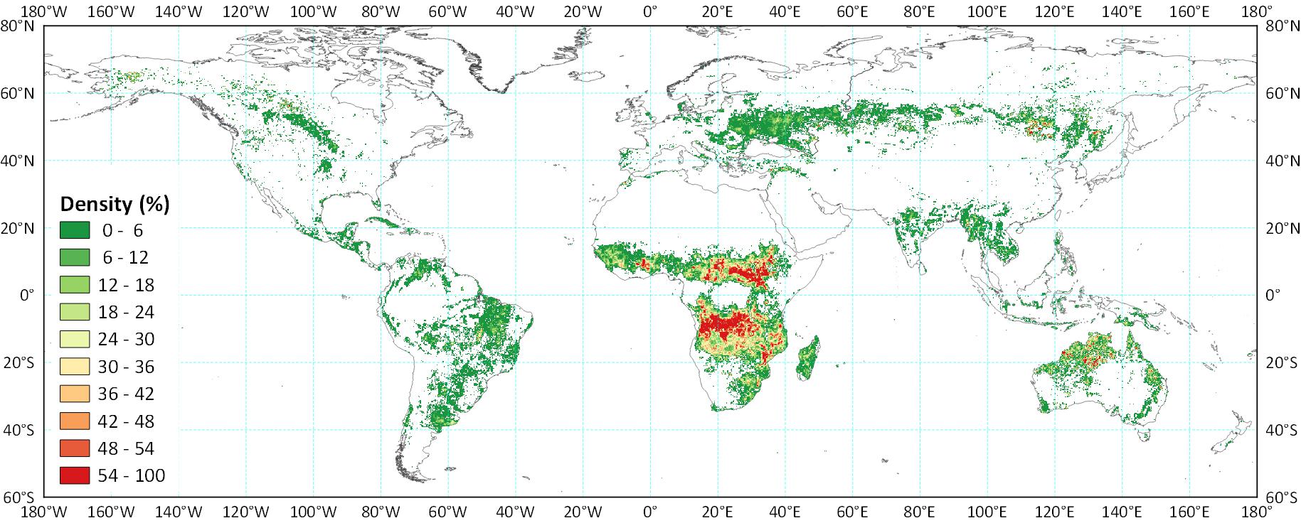
下图展示了 GABAM 2015 全球火烧迹地面积(BA)密度的分布情况。火烧迹地面积密度定义为 0.25°×0.25°网格中被烧毁像素所占的比例。
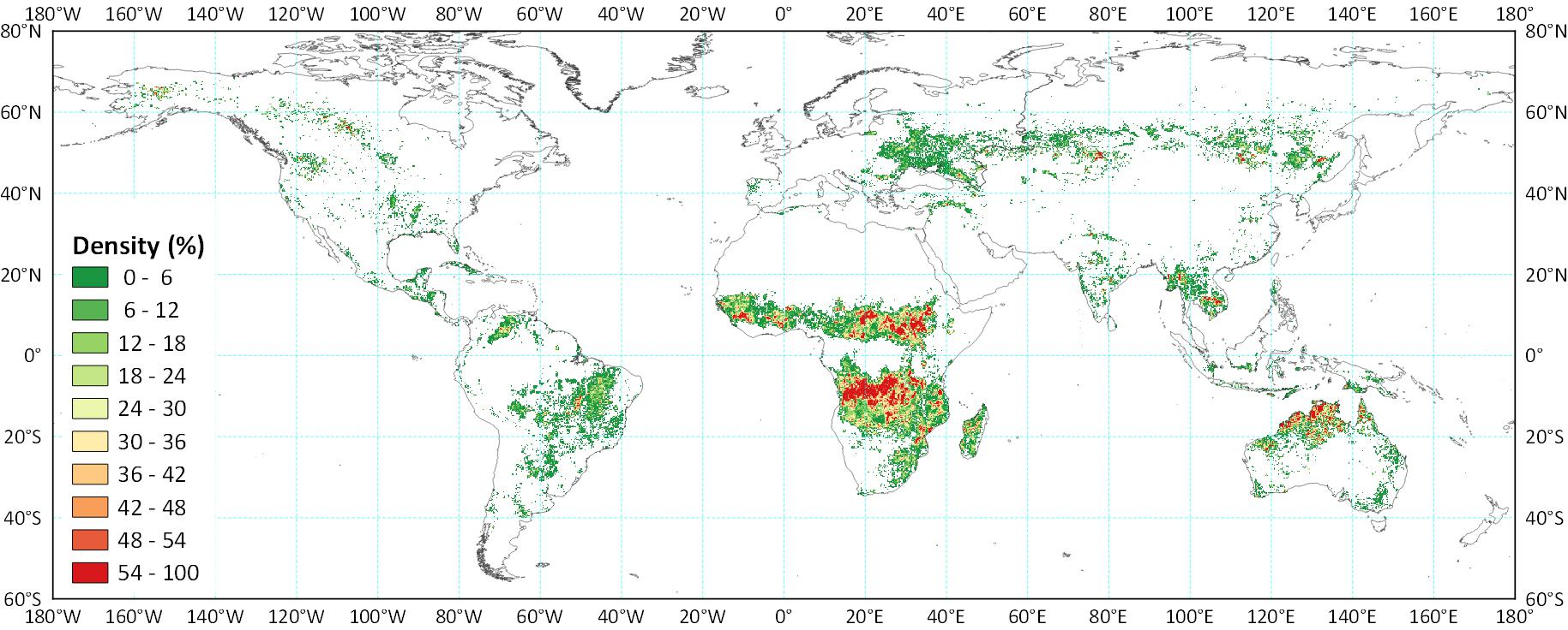
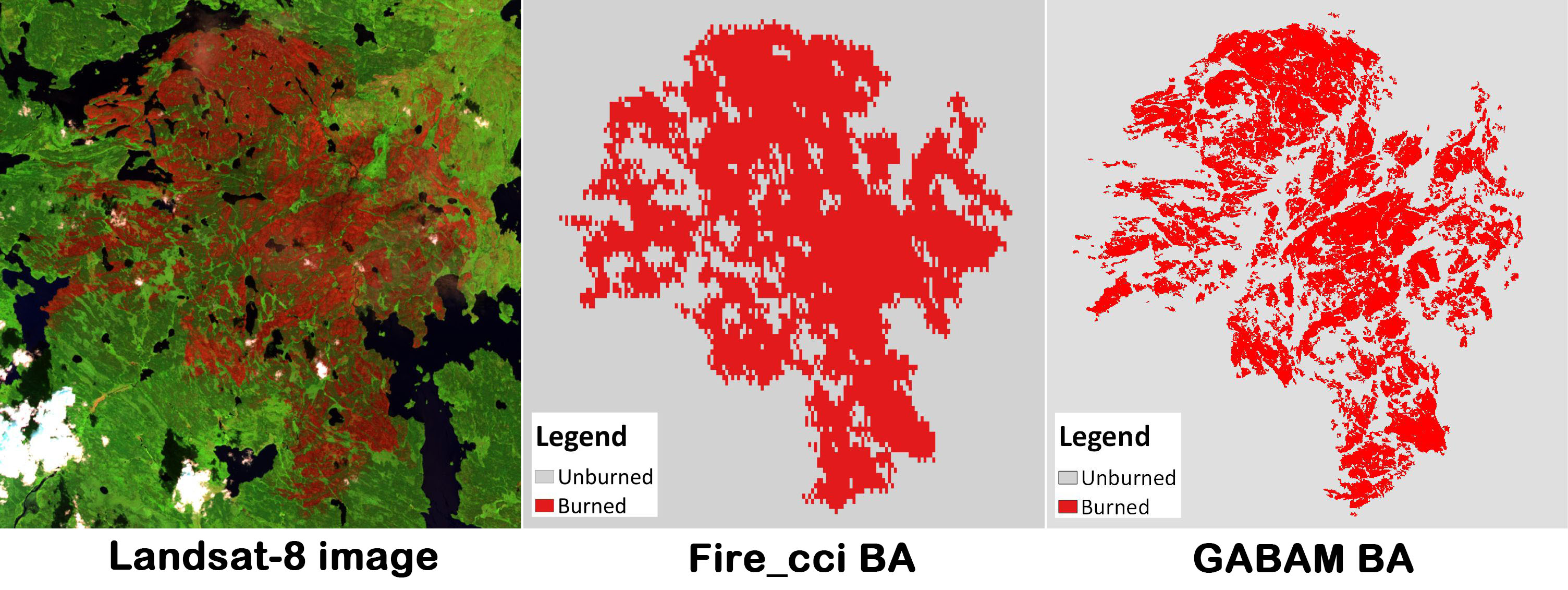
以下是与近期发布的 Fire_cci 5.0 版1 全球 BA 产品(分辨率为 250 米,是 GABAM 发布前分辨率最高的全球产品)的对比:
下载方式
GABAM 数据集可从 Zenodo.
引用信息
如需使用该数据集,请引用以下论文:
@article{Long_2019,
doi = {10.3390/rs11050489},
url = {https://doi.org/10.3390%2Frs11050489},
year = 2019,
month = {feb},
publisher = {{MDPI} {AG}},
volume = {11},
number = {5},
pages = {489},
author = {Tengfei Long and Zhaoming Zhang and Guojin He and Weili Jiao and Chao Tang and Bingfang Wu and Xiaomei Zhang and Guizhou Wang and Ranyu Yin},
title = {30 m Resolution Global Annual Burned Area Mapping Based on Landsat Images and Google Earth Engine},
journal = {Remote Sensing}
}
Please feel free to contact us (longtf@radi.ac.cn), feedback is welcome!
Chuvieco, E., Lizundia-Loiola, J., Pettinari, M.L., Ramo, R., Padilla, M., Tansey, K., Mouillot, F., Laurent, P., Storm, T., Heil, A., & Plummer, S. (2018). Generation and analysis of a new global burned area product based on MODIS 250 m reflectance bands and thermal anomalies. Earth Systems Science Data, 10, 2015-2031. ↩︎